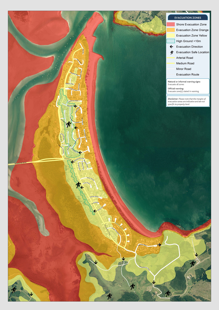
Geological investigations have identified the East Coast of New Zealand as a potential tsunami risk.
Tsunami waves are generated by earthquakes and the height of the waves depends on the magnitude and nature of the earthquake, as well as the distance from the New Zealand coast. Omaha Beach is to some extent protected by the Great Barrier and Little Barrier Islands but in the event of a serious tsunami wave heights could exceed 5 metres.
The Omaha Beach development is built on a sandspit and most properties are below the 10 metre contour line. The same applies to low lying areas of Point Wells, Omaha Flats and Whangateau. Land above the 12 metre contour may be considered relatively safe, for example in the vicinity of Caroline Heights. Signs have beeninstalled to indicate refuge areas above the 12 metre contour.
In the event that a general evacuation of Omaha Beach is required, the narrow causeway of Broadlands Drive could become choked with traffic, particularly during the peak holiday season. Furthermore, the traffic must merge with that from Point Wells and the Leigh Road. Therefore, alternative evacuation routes to high ground must be used.
What can happen?
There are two types of tsunami and you need to understand the difference.
- The first is a “near source” tsunami generated by an earthquake, underwater
landslide, or volcanic eruption close to the New Zealand coast. Your first, and
probably only, indication of a near source tsunami will be a major earthquake
(one that is hard to stand up in), unusual noises or changes in the ocean. - The second is known as a ”distal“ (distant) tsunami. It occurs far from New Zealand
and may take from three to twelve hours to arrive. Pacific monitoring ensures
that we have the maximum warning time possible, indication of wave height,
and arrival time.
What must I do in the case of a near source tsunami?
In the case of a large earthquake (one that is hard to stand up in) or you feel a weak rolling earthquake that lasts for more than a minute, unusual noises from the ocean (eg. the ocean rushing in or out), evacuate immediately on foot to the nearest high ground refuge zone. A wave may arrive within minutes or take an hour to arrive. The tsunami siren evacuate signal may sound if there is sufficient time:
Evacuate signal: DOT-DOT-DOT for 15 minutes.
From Area 1, north of Broadlands Drive.
Go to Caroline Heights.
From Area 2, south of Broadlands Drive to Pukemateko Reserve.
Go to high dunes west of Mangatawhiri Road.
From Area 3, between Pukemateko Reserve and Rahui Te Kiri Reserve.
Go to top of Old Quarry via path, south of golf course, and across bridge.
From Area 4, Taumata Road.
Go to Te Kie Point via path behind tennis courts.
Boats already at sea should stay as far off shore as possible.
Do not return to the Evacuation Zone until the official “all clear“ is given.
The key safety precaution is to keep away from the beach and low lying areas until the
danger has passed. Knowing what to do will save your life, and others near you.
- You must know your local Tsunami Action Plan.
- Know your nearest refuge ground area
- You and your family should have practised your escape route.
- Turn on your radio or TV for updates; listen to Times 88.9FM for local information.
- Make sure your neighbours are aware of the danger and assist them if necessary.
- If you are disabled, have impaired hearing or for any other reason may not be able to hear or react to a warning, please ensure your needs are known to someone.

THE OMAHA BEACH TSUNAMI PLAN
Be prepared, GET READY, GET THRU!
For information on how to prepare for emergencies see:
- the back pages of the Yellow Pages telephone directory.
- on the web: aucklandcivildefence.org.nz
Register to receive public alert notifications via smart phone App, SMS and/or email from Auckland Civil Defence by visiting www.aucklandcivildefence.org.nz.
